training analysis and race planning optimized specifically for trails and ultras.
The App Provides:
Analysis and coaching that accounts for terrain difficulty
Race planning, including accurate finish time projections, realistic splits, and detailed nutrition plans
Run planning to predict your time on a route and build your nutrition plan for the run
The Story Behind the App:
I have been a trail and ultra runner for over 20 years and a coach for 6 years. With a professional background in data science and analytics, I have always enjoyed the analytical side of the sport.
In my running and coaching, I consistently found two challenges that trail, mountain, and ultrarunners face:
Other apps did not accurately assess training and fitness on trails and hilly or mountainous terrain
It is extremely difficult to build a race plan - realistically predict finishing time, build accurate splits, and create a nutrition plan
Over many years I built metrics, algorithms, and frameworks to address both challenges, but it was manual and time-consuming to do even just for my own running. It wasn’t scalable even to the athletes I coach.
The Will to Run App was built to automate and improve this process. The goal: help trail, mountain, and ultra runners train better and prepare better for their races.


What does the app do?
Syncs with your Strava to load one year of activity history and automatically load all activities going forward.
Analyzes each run, mapping it to 335+ billion geospatial data points powered by satellite imagery, LiDAR, and trail surface mapping
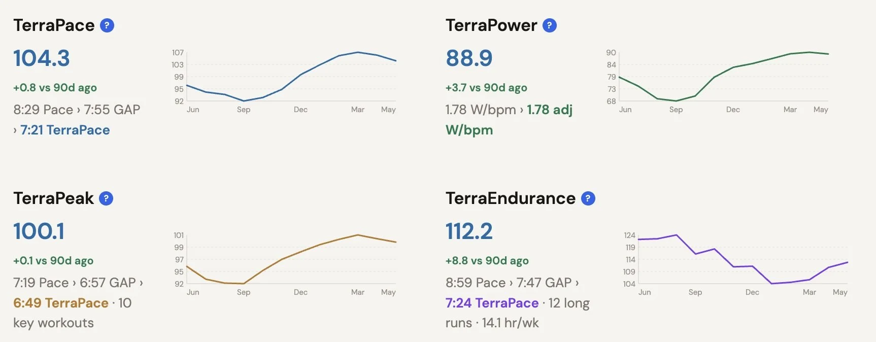
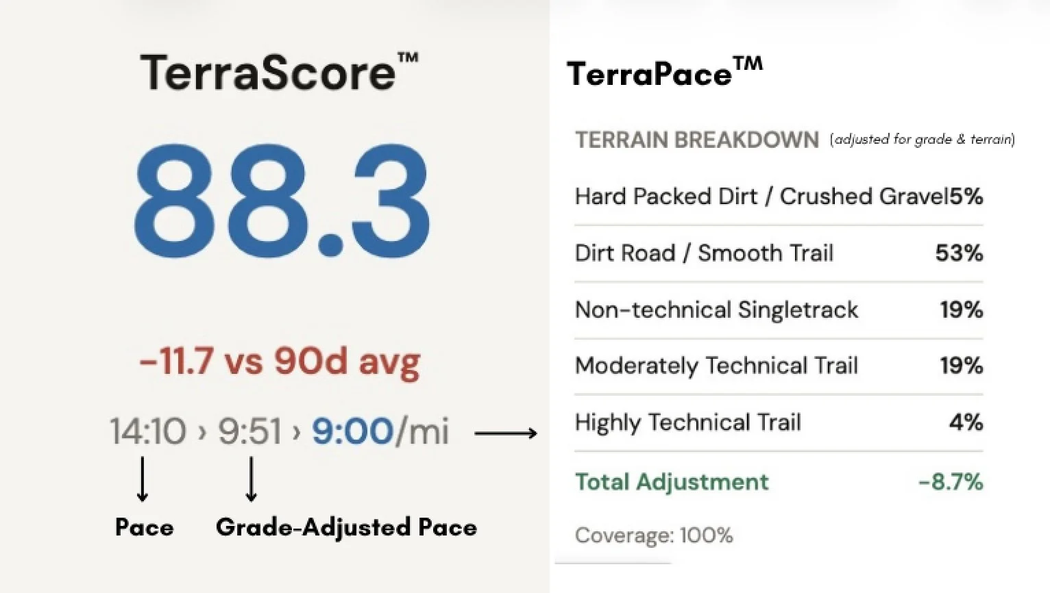
Calculates your training metrics, all of which are adjusted based on the terrain you ran on
Shows insights and trends to help you understand fitness and optimize training for your goals
Builds race plans with accurate projections, race splits, and nutrition plans
Plans for your training runs with estimated times and nutrition plans based on your route
Key Differentiators
Terrain-Aware Fitness Tracking & Analysis
For each run, the app analyzes terrain details and calculates adjusted metrics that reflect the true difficulty of your effort. Insights and analysis answers questions such as:
How did this run compare to my recent performance?
After adjusting for terrain, how is my fitness trending?
What are the main areas you should focus on to improve?
How does performance on a certain type of run (i.e. a long trail run) compare to similar types of runs?
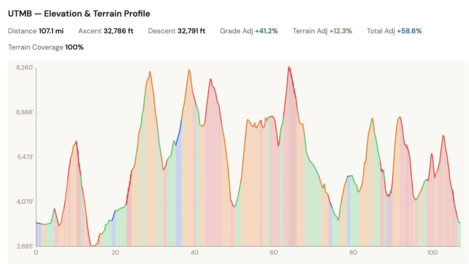
Race Prediction & Planning
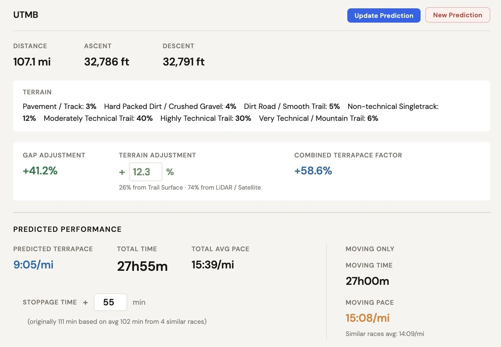
Unlike other tools, you don’t need to guess your finish time. The WilltoRun app gives you an accurate projection based on the race’s specific terrain and previous race performance.
Upload a GPX file for any race course and WillToRun will:
Analyze the elevation profile and terrain surface across the entire course
Predict your finish time based on your personal race history, adjusted for the specific grade and terrain of that course
Build section-by-section race splits with per-segment terrain adjustments, pace deterioration modeling, and aid station planning
Visualize the course with an interactive elevation and terrain profile
Build your nutrition plan for each race segment
Run Planner
Do you have a planned route but don’t know how long it will take you or how much nutrition you should bring?
Upload a GPX file for any route you plan to run, and the app will:
Analyze the elevation profile and terrain surface across the route
Predict your run time based on recent run performance and the specific grade and terrain of that route
Build your nutrition plan to optimize fueling
How to Get Started
Getting started takes less than two minutes.
1. Create an Account: Sign up at app.willtorun.com
2. Connect Your Strava Profile:
Link your Strava account with one click. WillToRun uses read-only access and never modifies your Strava data.
3. Connect to Stripe:
Stripe is the secure portal to manage your subscription and payment. You can cancel your subscription and remove your data at any time. Subscribe for $4.99 / month and use code W2RLAUNCH to try it free for a month.
ANY TERRAIN. TRAIN better. Race better.
WillToRun analyzes your runs against 335+ billion data points spanning satellite imagery, airborne LiDAR, and trail-level surface mapping to deliver terrain-aware coaching no other platform can match.